By Hatab Nyang and Louise Jobe
The Department of Lands and Surveys on Wednesday resumed the boundary demarcation exercise between Gunjur and Berending villages in Kombo South, erecting additional concrete poles to clearly mark territorial limits between the two communities.
This latest phase — Day Four of the ongoing effort — saw the erection of three new demarcation poles along mapped coordinates stretching from Berending towards Sifoe and Salla villages. Officials said the locations were guided by reference points identified in official survey maps.
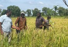
The demarcation team began their work from the eastern edge of Berending village, progressing through Tambakara Forest and extending to Alahin Bolong. They continued through areas near the Gambia Teachers’ Credit Union estate and the Gambia Armed Forces Credit Union estate, and eventually reached the rear of TAF Estate in Sifoe.
The mapping exercise, officials noted, reflects boundary separations between four kabilos (clans) within Gunjur and Berending. These specific divisions are key to resolving longstanding land disputes between the two neighboring communities.
The work resumed after a one-day delay due to heavy rains on Tuesday, July 15, which had forced the demarcation team to suspend operations. As of Day Four, the total number of boundary poles installed has reached twenty-two.
The demarcation exercise, coordinated by the Ministry of Lands through its Department of Lands and Surveys, is part of a broader government effort to resolve rural land disputes and prevent future conflict in Kombo South and surrounding areas.


